You can obtain information on permanently monumented control points including horizontal control, vertical control, High Accuracy Reference Network (HARN) stations, Calibration Baselines and retrieval software from the
National Geodetic Survey (NGS).
To plot NGS published control points in Google Earth, you can use DSworld, available from the NGS User Contributed software download page. Download kml files of control points by state, county, and type
here.
Maryland High Accuracy Reference Network (HARN)
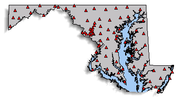
The map above shows the location of High Accuracy Reference Network (HARN) points in Maryland. The position of these points was determined by GPS observations and have a stated accuracy of 1.0 to 0.1 parts per million. NGS published these monuments as part of the North American Datum (NAD) of 1983, 1991 adjustment. The Maryland Department of Transportation State Highway Administration (MDOT SHA) uses these points and this horizontal datum for our existing projects.
Future Datums NGS is preparing a new Horizontal and a new Vertical Datum in the year 2025 to replace the NAD of 1983 and the North American Vertical Datum (NAVD) of 1988. MDOT SHA is aware of this change an is making plans on how to address it.
For more information on the new datums click
here.
Control Points
MDOT SHA uses methods from Static Post-processed Global Navigation Satellite System (GNSS), formerly known as Global Positioning System (GPS), to establish survey control points for highway development and system preservation projects. We typically use 5/8" rebar with caps for GPS control points. The horizontal coordinates are in the Maryland State Plane Coordinate System on the North American Datum of 1983, 1991 adjustment (NAD 83/91). The vertical coordinate, if applicable, is on the North American Vertical datum of 1988 (NAVD 88). There is an extensive network of points available for the public surveying community. Download a KML file to plot MDOT SHA GPS Control points in Google Earth or another mapping product (links to the images are not currently available; contact us with a point name and general location and we'll provide the information).
The file is available for download here (299 Kb).
For additional information, contact
MDOT SHA Control Points.
EDM Calibration Baselines in Maryland
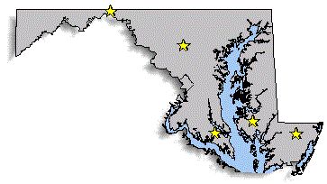
The map above shows the approximate location of the EDM (Electronic Distance Measuring system) calibration baselines located in Maryland. A calibration baseline consists of a set of very stable survey monuments that are accurately measured using specialized equipment. By comparing their results with the values published for the monuments, surveyors can verify the accuracy of their equipment.
Note: A new baseline has been installed in Warwick, Cecil County however that information is not available on the NGS website as of yet. For information about it please contact MDOT SHA Plats and Surveys Division
Calibration Baselines in Aberdeen and Hagerstown were destroyed by construction. One or two of the marks in each may remain, but they are unsuitable for calibration.